Archivo:CairoIL from space annotated.jpg

De Hispanopedia
Archivo original (1000 × 750 píxeles; tamaño de archivo: 583 kB; tipo MIME: image/jpeg)

Este archivo es de Wikimedia Commons y puede usarse en otros proyectos. La descripción en su página de descripción del archivo se muestra debajo.

Resumen

Descripción

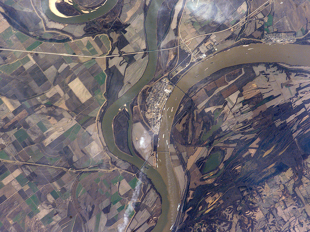
Astronaut photo of the confluence of the Mississippi and Ohio Rivers at Cairo, Illinois.


International Space Station InsigniaISS Crew Earth Observations: ISS012-E-15035International Space Station emblem
Identification
Mission ISS012 (Expedition 12)
Roll E
Frame 15035
Country or Geographic Name USA-ILLINOIS
Features CAIRO, MISSISSIPPI R., OHIO R.
Center Point Latitude 37.0° N
Center Point Longitude -89.2° E
Camera
Camera Tilt 17°
Camera Focal Length 400 mm
Camera Kodak DCS760C Electronic Still Camera
Film 3060 x 2036 pixel CCD, RGBG array.
Quality
Percentage of Cloud Cover 0-10%
Nadir What is Nadir?
Date 2006-01-12
Time 18:38:03
Nadir Point Latitude 37.2° N
Nadir Point Longitude -88.3° E
Nadir to Photo Center Direction West
Sun Azimuth 190°
Spacecraft Altitude 185 nautical miles (343 km)
Sun Elevation Angle 31°
Orbit Number 867
Original image caption
The Ohio River becomes a tributary of the Mississippi River directly south of Cairo, Illinois, a small city on the spit of land where the rivers converge (at center of this astronaut photograph). Brown, sediment-laden water flowing generally northeast to south from the Ohio River is distinct from the green and relatively sediment-poor water of the Mississippi River (flowing northwest to south). The color of the rivers in this image is reversed from the usual condition of a green Ohio and a brown Mississippi. This suggests that the very high rainfall in December 2005 over the Appalachians and the northeastern United States has led to greater-than-normal amounts of sediment in the rivers and streams of the Ohio River watershed. The distinct boundary between the two river’s waters indicates that little to no mixing occurs even 5-6 kilometers (3-4 miles) downstream.


Cairo became a prosperous port following the Civil War due to increased riverboat and railroad commerce. Small features visible in the image on the Ohio are river barges, which indicate the continued importance of Cairo as a transport hub. Flooding of the Ohio and Mississippi Rivers presents a continual danger to the city; this danger is lessened by the Birds Point-New Madrid Floodway that begins directly to the south of the river confluence. During major flood events, the floodway lessens flood stages upstream (such as at Cairo) and adjacent to the floodway. Part of the extensive levee system associated with flood control of the Mississippi River is visible in the image. Barlow Bottoms (image right), located in adjacent Kentucky, is a wetland bird-watching location that is replenished by periodic floods and releases of Ohio River water.

Fecha
Fuente http://earthobservatory.nasa.gov/Newsroom/NewImages/images.php3?img_id=17177
Autor ISS Crew Earth Observations experiment and the Image Science & Analysis Group, Johnson Space Center, NASA
Permiso
(Reutilización de este archivo)
US government, public domain

Licencia

Public domain
"The Gateway to Astronaut Photography of Earth". Imagen cortesía de Image Science & Analysis Laboratory, NASA Johnson Space Center.
Fuente de la foto: ISS012-E-15035.

العربيَّة | Deutsch | English | español | français | italiano | kurdî | македонски | മലയാളം | Nederlands | português | sicilianu | +/−

Annotations
InfoField
This image is annotated: View the annotations at Commons

Leyendas

Añade una explicación corta acerca de lo que representa este archivo

Elementos representados en este archivo

representa a

image/jpeg

8cc66c5fccbb4e8309770365ef1721ddb4c26885

750 píxel

1000 píxel

Historial del archivo

Haz clic sobre una fecha y hora para ver el archivo tal como apareció en ese momento.

Fecha y horaMiniaturaDimensionesUsuarioComentario
actual19:54 9 sep 2010Sin miniatura1000 × 750 (583 kB)wikimediacommons>Holly Chengoriginal photo

La siguiente página usa este archivo:

Metadatos