| Contenidos de Wikipedia en español bajo licencia CC BY-SA 4.0 ⇔ Mapas de OpenStreetMap bajo licencia ODbL |
Archivo:China map.png
De Hispanopedia
Archivo original (705 × 705 píxeles; tamaño de archivo: 135 kB; tipo MIME: image/png)
Resumen

|
File:China map.svg es una versión vectorial de este archivo. Debería usarse esa versión en lugar de este archivo PNG, cuando sea mejor.
File:China map.png → File:China map.svg
Para más información, lee Ayuda:SVG. |
 |
| Descripción |
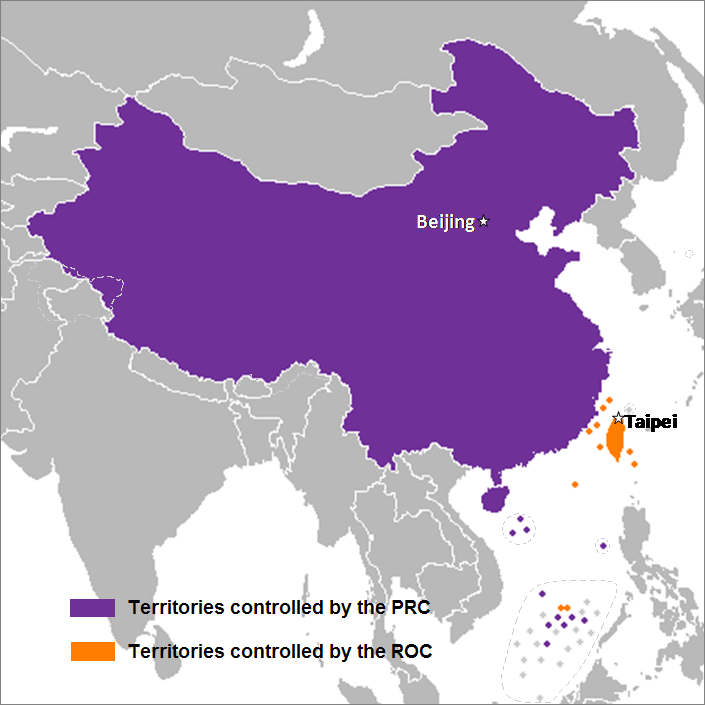
English: This is a map of the two states that officially use the name "China" in their names and depicts the actual "line of control" and not any claims that states often make. Key words: actual administration and actual maintaining of control of the territories.
中文(简体):这是一个关于两个都把“中华”用在自己的国名里的国家的地图,这个地图描绘了两国的实际“控制线”并跟两国通常声称的完全不是一回事。关键词:实际管辖和维持实际控制区域。
中文(繁體):中華民國與中華人民共和國的實控區域圖 |
| Fecha | 24 de septiembre de 2007 (fecha original de carga) |
| Fuente | Transferido desde en.wikipedia a Commons por Sreejithk2000 usando CommonsHelper. |
| Autor | Nat de Wikipedia en inglés |
Licencia
Nat de Wikipedia en inglés, titular de los derechos de autor de esta obra, la publica en los términos de las siguientes licencias:

|
Se autoriza la copia, distribución y modificación de este documento bajo los términos de la licencia de documentación libre GNU, versión 1.2 o cualquier otra que posteriormente publique la Fundación para el Software Libre; sin secciones invariables, textos de portada, ni textos de contraportada. Se incluye una copia de la dicha licencia en la sección titulada Licencia de Documentación Libre GNU. |


Este archivo se encuentra bajo la licencia Atribución 3.0 No portada de Creative Commons.
Atribución:
- Eres libre:
- de compartir – de copiar, distribuir y transmitir el trabajo
- de remezclar – de adaptar el trabajo
- Bajo las siguientes condiciones:
- atribución – Debes otorgar el crédito correspondiente, proporcionar un enlace a la licencia e indicar si realizaste algún cambio. Puedes hacerlo de cualquier manera razonable pero no de manera que sugiera que el licenciante te respalda a ti o al uso que hagas del trabajo.
Puedes usar la licencia que prefieras.
Registro original de carga
Aquí se muestra la página de descripción original. Los siguientes nombres de usuario se refieren a en.wikipedia.
- 2008-05-29 22:44 Shibo77 705×705× (136871 bytes)
- 2008-05-29 21:59 Shibo77 705×705× (135686 bytes)
- 2008-05-29 21:53 Shibo77 705×705× (132630 bytes) Reverted to version as of 00:46, 16 May 2008
- 2008-05-29 08:51 Sontung007 556×537× (31782 bytes) Reverted to the neutral version to avoid disputes and ambiguity
- 2008-05-16 00:46 Taktser 705×705× (132630 bytes)
- 2008-05-16 00:44 Taktser 705×705× (132710 bytes)
- 2008-05-03 20:22 T-1000 705×705× (115888 bytes) Reverted to version as of 22:31, 4 April 2008
- 2008-04-08 17:10 Heavyrain2408 705×705× (129360 bytes) Chinese people use tricky word "administration" to mislead readers to believe these islands belonging to them. Please stop these kinds of actions.
- 2008-04-04 22:31 Taktser 705×705× (115888 bytes) Reverted to version as of 20:02, 27 March 2008 (administration is clearly stated, not the question of sovereignty over these territories, Arunachal Pradesh is excluded; Aksai Chin, the Spratly islands and some of the Paracel islands are included)
- 2008-03-30 05:36 Heavyrain2408 705×705× (129360 bytes) Constroversary parts should not be included. This could result readers think that these parts belong to China.
- 2008-03-27 20:02 Taktser 705×705× (115888 bytes) Reverted to version as of 20:31, 10 March 2008 It's clearly stated as administration not sovereignty
- 2008-03-21 21:11 Sontung007 705×705× (129360 bytes) the previous map wrongly included unresolved disputed islands
- 2008-03-10 20:31 Taktser 705×705× (115888 bytes) Reverted to version as of 16:33, 16 November 2007
- 2008-01-24 15:26 Sinoevils 705×705× (129360 bytes) This is the real China Map
- 2008-01-24 15:24 Sinoevils 705×705× (129360 bytes) This is the real China Map
- 2007-11-16 16:33 Nat 705×705× (115888 bytes)
- 2007-11-06 18:53 Nat 556×537× (30702 bytes)
- 2007-11-05 22:48 Nat 556×537× (33377 bytes)
- 2007-10-28 07:25 Jjhcap99 556×537× (31782 bytes) Added country names.
- 2007-10-19 22:35 Jerrch 556×537× (30043 bytes) Capitalized the capitals
- 2007-10-16 22:23 Nat 556×537× (30403 bytes) Reverted to version as of 19:37, 9 October 2007
- 2007-10-16 20:34 Jerrch 556×537× (30411 bytes) Reverted to version as of 19:56, 29 September 2007
- 2007-10-15 13:05 Jjhcap99 556×537× (33989 bytes)
- 2007-10-09 19:37 Nat 556×537× (30403 bytes) This is the work of {{user|Nat}}
- 2007-10-09 19:32 Nat 556×537× (32238 bytes) This is the work of {{User7|Nat}}.
- 2007-09-29 19:56 Jerrch 556×537× (30411 bytes) changed color a little bit to make it just a little more neutral.
- 2007-09-24 23:16 Nat 556×537× (30343 bytes)
- 2007-09-24 01:44 Nat 1127×1069× (958918 bytes)
| Annotations | This image is annotated: View the annotations at Commons |
Historial del archivo
Haz clic sobre una fecha y hora para ver el archivo tal como apareció en ese momento.
| Fecha y hora | Miniatura | Dimensiones | Usuario | Comentario | |
|---|---|---|---|---|---|
| actual | 08:14 15 dic 2014 | Sin miniatura | 705 × 705 (135 kB) | wikimediacommons>Shibo77 | .. |
Usos del archivo
La siguiente página usa este archivo: