| Contenidos de Wikipedia en español bajo licencia CC BY-SA 4.0 ⇔ Mapas de OpenStreetMap bajo licencia ODbL |
Archivo:Delaware Bay Vinckeboons 14.jpg

Resumen
| Descripción |
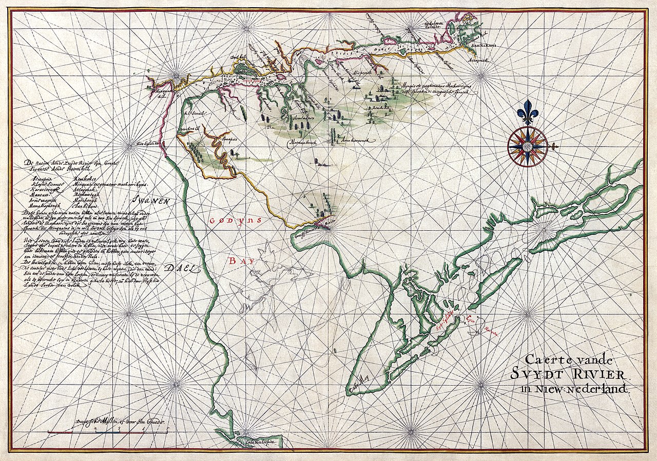
English: Nautical chart of Zwaanendael ("Swanendael") and Godyn's Bay in New Netherland. Zwaanendael was a patroonship founded by Samuel Godyn, a director of the Dutch West India Company, in 1629. Godyn made his land claim to the West India Company under jurisdiction of the Charter of Freedoms and Exemptions. After a short time, the initial 32 inhabitants were murdered by local Indians and Godyn sold his land back to the West India Company. The West India Company kept the names of the local area, including Godyn's Bay, which eventually became Delaware Bay. Ink and watercolor with pictorial relief.
The text in Dutch at left side of the map reads: De natien aende Zuydt Rivier syn Groote Sironese Aende Hoerenkil Sewapois Remkokes Kleyne Siconese Minquaen toegenaemt Machaorikyns. Naraticonck Atsayonck Mantaes Rechaweygh Armewamix Matikongh Momakavaongk Sankikans.
Het leeven van deese luyden is volcoomelyck vry. Hear waer segers ofte duyvelpreekers en hebben niet oover haer te seggen haer sakimaen hebben niet te gebieden ende hebben geen autoriteyt om iemant te straffen aen den hals. De huwelycken en hebben geen clem, meest heeft elck een vrouw., de ooverste meer. Ende licht verlaetten sy haer wyven, die dan vande een tot de ander voor hoer loopen, ordinary verstooten sy de vrouwen als sy bevrucht syn en kinderen gehaelt heeft, ende hier door blyft het lande soober van volck Translated: The nations at the South Rver are Great Sironese at the Hoerenkil Sewapois Remkokes Small Sironese Minquaen also named Machaorikyns. Naraticonck Atsayonck Mantaes Rechaweygh Armewamix Matikongh Momakavaongk Sankikans. These above described nations have friendships with each other. And are mostly one people with one language, with the exception of the Machaoretijns that are named like this because of their language that is Minquaens and is as much similar as with us old Dutch or Wallonian. The life of these people is totally free. Their soothsayers or devil preachers have nothing to say over them, their shamans can’t order them and have no authority to give someone a death penalty. The marriages are not fixed, most have one wife, the chief more than one. And they leave their women easily, and these will go from one to another like a whore, usually women are disowned after having a child and as a result the population remains low.Français : Carte nautique de la colonie de Zwaanendael ("Swanendael") et de la baie de Godyn, dans les Nouveaux-Pays-Bas. Zwaanendael était un domaine seigneurial fondé par Samuel Godyn, un directeur de la Compagnie néerlandaise des Indes occidentales en 1629. Godyn obtint ces terres de la Compagnie, sous le régime juridique de la Charter of Freedoms and Exemptions. Rapidement, les 32 habitants furent tués par les amérindiens du cru, et Godyn revendit sa terre à la Compagnie. Celle ci conserva la toponymie dont la « Baie de Godyn », aujourd'hui baie du Delaware. Encre et aquarelle avec représentation du relief. |
||||||||||||||||||||||
| Fecha | |||||||||||||||||||||||
| Fuente | Library of Congress[1] | ||||||||||||||||||||||
| Creador |
|
||||||||||||||||||||||
| Georeferencing | |||||||||||||||||||||||
| Otras versiones | Restored version of File:Delaware Bay Vinckeboons.jpg. Dirt, scratches, librarian's notes, and stains removed. Crease down centre flattened. Water damage corrected. Depigmented areas repigmented. Colors adjusted, with very extensive local adjustments to color balance, brightness, and contrast. Mild perspective crop. Histogram adjusted. See also File:Delaware Bay Vinckeboons 14 courtesy copy.jpg (more compressed restored version for viewers with slow connection speeds). | ||||||||||||||||||||||


|


Licencia

|
Este material está en dominio público en los demás países donde el derecho de autor se extiende por 100 años (o menos) tras la muerte del autor.  También debes incluir una etiqueta de dominio público de los Estados Unidos para indicar por qué esta obra está en el dominio público en los Estados Unidos. También debes incluir una etiqueta de dominio público de los Estados Unidos para indicar por qué esta obra está en el dominio público en los Estados Unidos.
|
| Esta obra ha sido identificada como libre de las restricciones conocidas en virtud del derecho de autor, incluyendo todos los derechos conexos. | |
Historial del archivo
Haz clic sobre una fecha y hora para ver el archivo tal como apareció en ese momento.
| Fecha y hora | Miniatura | Dimensiones | Usuario | Comentario | |
|---|---|---|---|---|---|
| actual | 16:21 18 oct 2009 | | 8382 × 5888 (34,25 MB) | wikimediacommons>Durova | {{picture of the day|year=2009|month=11|day=01}} {{Information |Description = Early nautical chart of Delaware Bay Ink and watercolor with pictorial relief. |Source = Library of Congress[http://hdl.loc.gov/loc.gmd/g3291s.mf000074] |Date |
Usos del archivo
La siguiente página usa este archivo: