| Contenidos de Wikipedia en español bajo licencia CC BY-SA 4.0 ⇔ Mapas de OpenStreetMap bajo licencia ODbL |
Archivo:NYC subway-4D.svg
De Hispanopedia

Tamaño de esta previsualización PNG del archivo SVG: 512 × 553 píxeles. Otras resoluciones: 222 × 240 píxeles | 444 × 480 píxeles | 711 × 768 píxeles | 948 × 1024 píxeles.
Archivo original (archivo SVG, nominalmente 512 × 553 píxeles, tamaño de archivo: 2,63 MB)
Resumen
| Descripción |
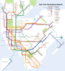
Čeština: Plán sítě newyorského metra Deutsch: Netzplan der New Yorker U-Bahn English: Map of the New York City Subway Español: Plano del Metro de Nueva York Français : Carte du métro de New York Română: Hartă a metroului din New York 中文: 纽约地铁路线图 |
| SVG desarrollo | |
| Fecha | |
| Fuente | I created this work entirely by myself. Subway service information taken from the MTA. |
| Creador |
I, User:CountZ, Jake Berman. A link to my website, [1] would also be appreciated if you reuse this file. |
| Georeferencing | If inappropriate please set warp_status = skip to hide. |
| Otras versiones | File:NYC_subway-4C.svg, File:NYC_subway-4b-shrunk-2.svg |

Licencia
CountZ de Wikipedia en inglés, titular de los derechos de autor de esta obra, la publica en los términos de la siguiente licencia:
Este archivo se encuentra bajo la licencia Creative Commons Genérica de Atribución/Compartir-Igual 3.0.
Atribución:
- Eres libre:
- de compartir – de copiar, distribuir y transmitir el trabajo
- de remezclar – de adaptar el trabajo
- Bajo las siguientes condiciones:
- atribución – Debes otorgar el crédito correspondiente, proporcionar un enlace a la licencia e indicar si realizaste algún cambio. Puedes hacerlo de cualquier manera razonable pero no de manera que sugiera que el licenciante te respalda a ti o al uso que hagas del trabajo.
- compartir igual – En caso de mezclar, transformar o modificar este trabajo, deberás distribuir el trabajo resultante bajo la misma licencia o una compatible como el original.
Valoración
|
Esta imagen ha sido seleccionada como la Imagen del día el 8 de octubre de 2011. Fue descrita como sigue: Español: Mapa del Metro de la Ciudad de Nueva York (EE.UU.) Otros idiomas:
Čeština: Plán sítě newyorského metra s anglickými popisky, stav říjen 2011 Dansk: Kort over New York City Subway. English: Map of the New York City Subway Español: Mapa del Metro de la Ciudad de Nueva York (EE.UU.) Français : Carte du métro de New York Italiano: Mappa della metropolitana di New York. Magyar: New York-i metró térképe. Nederlands: Kaart van de metro van New York Română: Hartă a metroului din New York. Русский: Схема Нью-йоркского метрополитена Українська: Карта Нью-Йоркського метрополітену. 한국어: 뉴욕 지하철 노선도. 日本語: ニューヨーク市の地下鉄路線図 中文: 纽约地铁线路图。 |
Registro original de carga
Transferido desde en.wikipedia a Commons por Train2104 usando CommonsHelper.
Aquí se muestra la página de descripción original. Los siguientes nombres de usuario se refieren a en.wikipedia.
- 2011-02-16 23:04 CountZ 2500×2700 (3397859 bytes) minor modifications
- 2011-02-04 21:28 CountZ 2500×2700 (3381913 bytes) added neighborhoods and borough lines
- 2011-01-20 16:12 CountZ 2500×2700 (3072936 bytes) Modified Staten Island service to show ferry connections; clarified Times Sq wheelchair access
- 2011-01-15 22:33 Train2104 2500×2700 (5298094 bytes) Corrected naming of certain stations, line color to match {{NYCS color}}, Ballpark closed
- 2011-01-11 17:29 CountZ 2500×2700 (3075835 bytes) rearranged herald square, fixed PATH stations
- 2011-01-11 00:18 CountZ 2500×2700 (3053095 bytes) Past upload did not upload correctly.
- 2011-01-11 00:13 CountZ 2500×2700 (3052896 bytes) Corrected error on the Broadway Line
- 2011-01-10 21:23 CountZ 2500×2700 (3232134 bytes) comprehensive rework of the map
- 2010-12-31 17:11 CountZ 2500×2700 (3234151 bytes) Updated Nostrand Avenue service pattern
- 2010-12-11 17:11 CountZ 2500×2700 (3230578 bytes) Added Jay Street-Lawrence Street transfer Renamed Fulton-Broadway-Nassau to its new name (Fulton Street)
- 2010-09-23 15:03 CountZ 2500×2700 (3237347 bytes) minor updates, including B/Q on the Brighton Line
- 2010-05-31 15:26 CountZ 2500×2700 (3213246 bytes) minor edits for new service changes
- 2010-04-16 17:44 CountZ 2500×2700 (3199398 bytes) Updated to reflect MTA service changes
- 2010-03-02 21:34 CountZ 2500×2700 (3222199 bytes) minor update to test Illustrator
- 2010-01-18 22:20 CountZ 2500×2700 (3237236 bytes) Update: Added Staten Island express service.
- 2009-12-20 19:08 Dream out loud 2500×2700 (4410399 bytes) fixed blue (water) background
- 2009-12-19 03:10 Dream out loud 2500×2700 (4385399 bytes) updated 4 Oct 2009 edit - cleaned up AirTrain JFK, added endashes, updated Aqueduct Racetrack and Cortlandt St BMT
- 2009-11-25 06:58 Dream out loud 2500×2700 (4010699 bytes) converted text to path
- 2009-11-25 06:52 Dream out loud 2500×2700 (3950043 bytes) added endashes to subway services, fixed AirTrain JFK stations
- 2009-11-17 17:05 Dream out loud 2500×2700 (3481944 bytes) added northbound service only for Aqueduct Racetrack
- 2009-10-04 13:53 CountZ 2500×2700 (3218417 bytes) Minor edit: slightly untangled the Eastern Pkwy line.
- 2009-09-30 13:49 CountZ 2500×2700 (3216925 bytes) Minor edit: AirTrain JFK station names fixed.
- 2009-09-30 02:17 CountZ 2500×2700 (3200805 bytes) Okay, it should work this time. Was uploading the wrong file version.
- 2009-09-30 02:12 CountZ 2500×2700 (3196471 bytes) Funny, it didn't remove. Let's try again.
- 2009-09-30 02:06 CountZ 2500×2700 (3196471 bytes) Watermark removed
- 2009-09-27 15:25 CountZ 2500×2700 (3195870 bytes) Fixed a couple of street names: 9 -> 9 St; 125 -> 125 St; 8 St -> 8 St/ NYU
- 2009-09-27 15:16 CountZ 2500×2700 (3196585 bytes)
- 2009-09-27 14:48 CountZ 2500×2700 (3195913 bytes) Corrected j-z skip-stop service in Brooklyn.
- 2009-09-26 20:23 CountZ 2500×2700 (3197825 bytes) {{Information |Description = Map of the New York Subway |Source = I (~~~) created this work entirely by myself. Also: [http://www.mta.info/nyct/maps/submap.htm] |Date = ~~~~~ |Author = ~~~ |other_versions = [[:File:NYC_su
Historial del archivo
Haz clic sobre una fecha y hora para ver el archivo tal como apareció en ese momento.
| Fecha y hora | Miniatura | Dimensiones | Usuario | Comentario | |
|---|---|---|---|---|---|
| actual | 06:39 8 dic 2022 | Sin miniatura | 512 × 553 (2,63 MB) | wikimediacommons>TFSyndicate | Added more 'accessible station' symbols |
Usos del archivo
La siguiente página usa este archivo:
