| Contenidos de Wikipedia en español bajo licencia CC BY-SA 4.0 ⇔ Mapas de OpenStreetMap bajo licencia ODbL |
Archivo:PIA16064-Mars Curiosity Rover Treasure Map.jpg
Resumen
| Descripción |
English: 08.17.2012
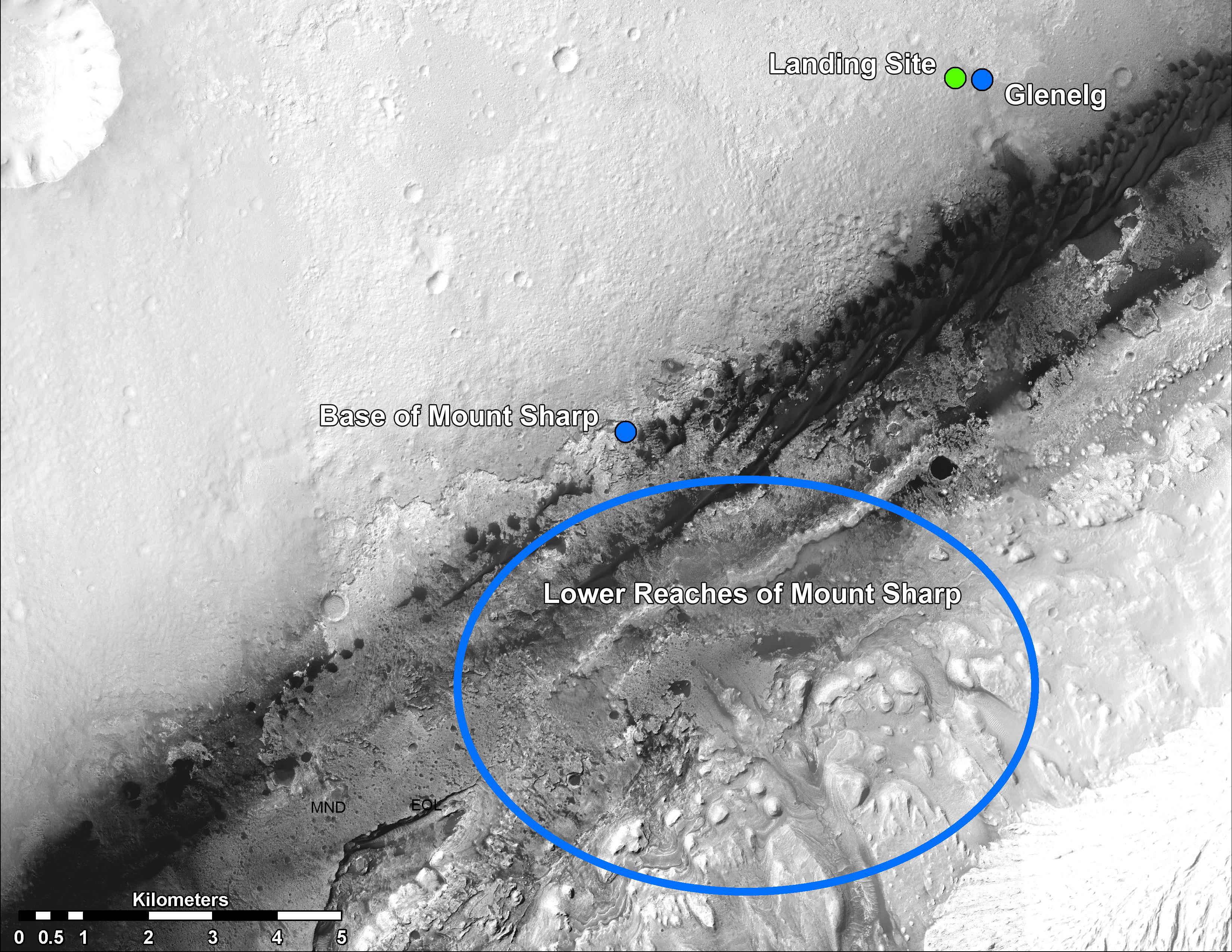
Martian Treasure Map This image shows the landing site of NASA's Curiosity rover and destinations scientists want to investigate. Curiosity landed inside Gale Crater on Mars on Aug. 5 PDT (Aug. 6 EDT) at the green dot, within the Yellowknife quadrangle. The team has chosen for it to move toward the region marked by a blue dot that is nicknamed Glenelg. That area marks the intersection of three kinds of terrain. The science team thought the name Glenelg was appropriate because, if Curiosity traveled there, it would visit it twice -- both coming and going -- and the word Glenelg is a palindrome. Then, the rover will aim to drive to the blue spot marked "Base of Mt. Sharp", which is a natural break in the dunes that will allow Curiosity to begin scaling the lower reaches of Mount Sharp. At the base of Mt. Sharp are layered buttes and mesas that scientists hope will reveal the area's geological history. These annotations have been made on top of an image acquired by the High Resolution Imaging Science Experiment (HiRISE) camera on NASA's Mars Reconnaissance Orbiter. Polski: Trasa przemarszu łazika Curiosity pokazuje lądowisko i docelowe miejsca badań naukowców NASA . Curiosity wylądował wewnątrz krateru Gale (Bradbury Landing) 5 sierpnia PDT (06 sierpnia EDT) w miejscu oznaczonym zieloną kropką, w czworoboku Yellowknife. Zespół postanowił , aby poruszać się w kierunku regionu oznaczonego niebieską kropką, jest nazywanego Glenelg. Obszar ten wyznacza punkt przecięcia trzech rodzajach terenu. Naukowy zespół uznał, że nazwa Glenelg była właściwa, ponieważ Curiosity podczas podróży odwiedziłby to miejsce dwa razy - zarówno przychodząc jak i odchodząc, a słowo Glenelg jest palindromem. Następnie, łazik będzie poruszać się do miejsca oznaczonego niebieskim owalem "Baza Mt. Sharpa", która jest naturalną przerwą w wydmach, które pozwolą rozpocząć poruszanie się łazika w kierunku dolnego odcinka Mount Sharp (Aeolis Mona). U podnóża Mount Sharp są wzgórza warstwowe i płaskowyże, tak że naukowcy mają nadzieję ujawnić historię geologiczną tego obszaru.
Image Credit: NASA/JPL-Caltech/Univ. of Arizona |
| Fecha | |
| Fuente | http://photojournal.jpl.nasa.gov/jpeg/PIA16064.jpg |
| Autor | NASA/JPL-Caltech/Univ. of Arizona |
| Otras versiones | http://photojournal.jpl.nasa.gov/catalog/PIA16064 |
Licencia

|
This media was created by the Jet Propulsion Laboratory (JPL) at Caltech. Their website states: "Unless otherwise noted, images and video on JPL public web sites (public sites ending with a jpl.nasa.gov address) may be used for any purpose without prior permission, subject to the special cases noted below. Publishers who wish to have authorization may print this page and retain it for their records; JPL does not issue image permissions on an image by image basis." Conditions:
According to JPL's image use policy additional restriction is that no endorsement of any product or service by Caltech, JPL or NASA is claimed or implied. Caltech's disclaimer: Caltech makes no representations or warranties with respect to ownership of copyrights in the images, and does not represent others who may claim to be authors or owners of copyright of any of the images, and makes no warranties as to the quality of the images. Caltech shall not be responsible for any loss or expenses resulting from the use of the images, and you release and hold Caltech harmless from all liability arising from such use. Usage on the English Wikipedia: On the English Wikipedia you can use the {{JPL Image}} template to display the copyright notice. (See Wikipedia:Using JPL images for details)
|
  |
| Annotations | This image is annotated: View the annotations at Commons |
Historial del archivo
Haz clic sobre una fecha y hora para ver el archivo tal como apareció en ese momento.
| Fecha y hora | Miniatura | Dimensiones | Usuario | Comentario | |
|---|---|---|---|---|---|
| actual | 23:45 21 ago 2012 |  | 3300 × 2550 (1,63 MB) | wikimediacommons>Drbogdan |
Usos del archivo
La siguiente página usa este archivo: